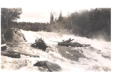
A visit to Aguasabon Falls and Gorge just west of the small North Shore community of Terrace Bay, Ontario, is a must! For many, a waterfall is a feast for the senses: hearing the roar of the falls, watching the water tumbling over ancient high cliffs, pointing out the rainbow colours as sunlight passes through mist droplets, feeling the spray against your face. Aguasabon Falls is particularly impressive, cascading 30 m (100 feet)in a narrow gorge, past a rock face that’s billions of years old. Fiercer in the spring, gentler in the summer and fall and intriguingly icy in the winter, it’s an awe-inspiring sight that happens to be easy to access from the Trans-Canada Highway and is also part of the Lake Superior Circle Tour route. As well, Augasabon Falls is linked to incredible feats of engineering to harness the power of the water and contribute to founding of the town of Terrace Bay. Read on to discover more about the fascinating history of Aguasabon Falls and Gorge.
Related Article: A History of Terrace Bay
Going Way Back
The geology of Augasabon Falls and Gorge dates back to 2.5 billion years ago and the Archean age. The exposed rock you see at the falls is igneous rock called granodiorite, made up of mainly feldspar and quartz. Brittle fractures called joints cross this granodiorite rock, and over millions of years, as the earth shifted, these joints grew larger. During the last ice age, about 10,000 years ago, this landscape was further shaped by glaciers—as the glaciers melted, the heavy pressure of the ice on the earth’s crust began to ease (called “uplift”), leading to even wider joints. The combination of uplift and longtime erosion helped create the landscape you see today. Joints form the vertical walls of the gorge as well as parallel to the river above the falls, causing the pronounced right-angle bend in the river. Be sure to check out the interpretative panels at the lookout for more details about the geology of the area.

Longtime First Nation Residents
Lake Superior is known as gichigaaming (the big lake) to the Anishinaabeg peoples who live on its shores. Archeological evidence shows that Indigenous peoples have lived and travelled on the lake’s shoreline and islands for about 9,500 years, paying close attention to the lands, waters, weather and seasons. As Parks Canada notes, “Their relationship to, and stewardship of, the land is reflected in ceremony, songs, craft and language. As you travel along the highway corridor, you will see place names that are rooted in the Ojibwe language. Examples include: Shuniah, Nipigon, Opwaaganasiniing, Mazukama Falls, Kama Cliffs, Wabasta Lake, Pawgwasheeng, and Aguasabon Falls.”
Remarkable Engineering
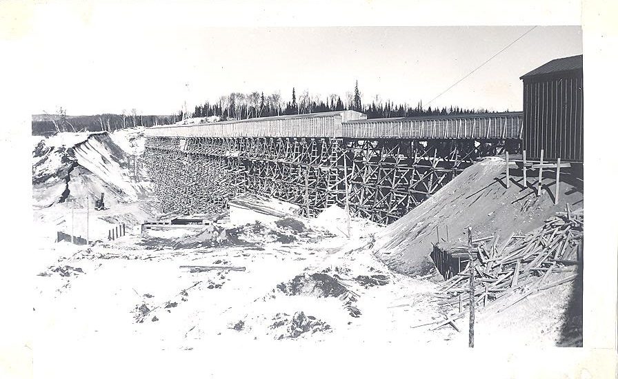
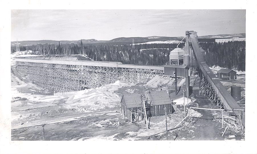
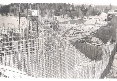
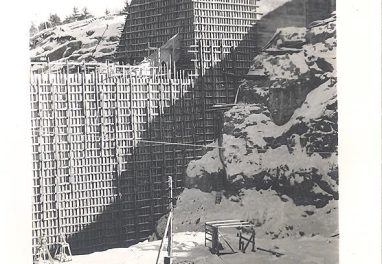
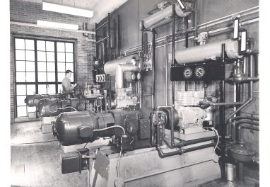
The Augasabon River looked very different a hundred years ago. In 1939, however, the quiet Augasabon stream became a rushing river, when the north end of Long Lake was dammed by the Hydro-Electric Power Commission of Ontario (the predecessor of Ontario Power Generation or OPG). Now, water flows southward into Lake Superior, rather than northward to James Bay via the Kenogami River. This actually raised the water levels of Lake Superior and the other Great Lakes! Then, in 1945, power commission gave the green light to the construction of a 40,000 kilowatt (53,000 horsepower) generating station. The hydroelectric power derived from the Augasabon Generating Station meant that the growing industrial demands of the area—mainly the new mill of the Long Lac Pulp and Paper Company, later the Kimberly-Clark Pulp and Paper Company—could be met. Power was also supplied to the Thunder Bay area via a 110,000-volt steel transmission line.

Construction of the generating project began in spring 1946. A massive dam contained the waters of the Augasabon River, vastly enlarging a small lake called Blue Jay that was renamed Hays Lake, after Charles L. Hays, the general superintendent of the project. The dam, about 3 km (2 miles) north of the outlet to Lake Superior, is about 427 m (1,400 feet long) and 37 m (120 feet) high, containing three sluiceways, each 4 m (14 feet wide). The dam, the generating station and the intake structure are all at some distance from each other, presenting significant engineering challenges, not the least of which was excavating a 1,066-m (3,500-foot) tunnel through solid rock in order to transport water from the intake structure on Hays Lake to the powerhouse on Lake Superior. The entire project saw an average of 700 people working on it per day (with peak employment reaching 2,000 at times) for a total of 5,000,000 hours of labour. It officially opened in October 1948.
A New Town by the River
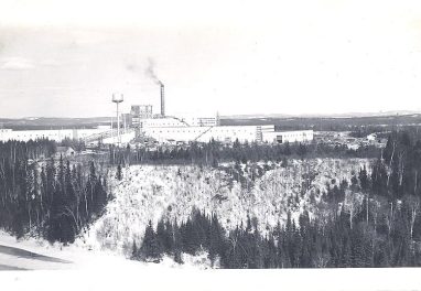
The new town of Terrace Bay also came into being (formerly the tiny railway settlement was known as Black Siding) as a site for the mill’s workforce and their families. An article in the July 8, 1948 Terrace Bay News reported that “History was made this morning at Terrace Bay when two steel gates in the newly constructed Hydro Dam across the Aguasabon River were lowered into position,” followed by comments by a mill representative that “he was thrilled beyond words” and “noted that with the closing of the gates in the dam a new era was beginning in this area where an entire new community was being built around a river.” By 1950, the population of Terrace Bay had settled out at about 2,000 residents, rising higher in the 1970s with a mill expansion and boom times, and then dropping to about 1,500 in 2021. While the mill operations have declined over the years, the Augasabon Generating Station continues to be one of OPG’s 11 hydroelectric generating stations in Ontario. It can power approximately 45,000 homes at peak capacity.

Aguasabon Falls and Gorge Today
Today, visitors and residents alike visit Aguasabon Falls and Gorge in all seasons, to contemplate the majesty of the rock and water. You can relax at the picnic tables, see the falls from a lookout and stroll the wheelchair accessible boardwalk (yes, there’s parking, including for RVs). Before or after your visit, see Terrace Bay itself to discover its amenities, including shopping, restaurants and a craft brewery, and the sandy shores of Terrace Bay Beach . To get a closer look at the Augasabon River, try the 3.25 km (2 mile) round-trip Terrace Bay Beach hike south from the falls and along the river to reach its end point at Terrace Bay Beach, or head northeast from the falls along the river and into the community of Terrace Bay, a round trip of 3.75 km (2.3 mile), on the Danny’s Cove Trail.
A History of Aguasabon Falls and Gorge Photos
Images courtesy of Catherine Swimming, Collection of Terrace Bay Public Library.


Posted by Bonnie Schiedel
Bonnie Schiedel is an award-winning freelance writer and editor for print and web.